
NEWS
NISAR Maps Lava From a Volcano Silent Since 1550
NISAR, the NASA-ISRO radar, built a 17-frame time-lapse of Kamchatka lava and showed how it will watch volcanoes that lack ground sensors.

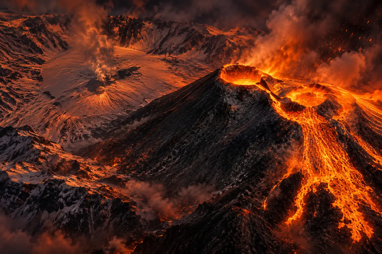
NISAR, a NASA-ISRO radar satellite, turned 17 passes over Kamchatka into a time-lapse of lava from a volcano silent since about 1550. The first look came on Dec. 25, 2025, while the craft was still finishing checkout, and later frames show molten rock filling a crater, spilling over, and spreading into a fan.
Kamchatka already wires many of its busy cones. Krasheninnikov sat quiet so long that it did not get the same instruments, and the US-India radar still caught every pass.
The Quiet Cone Kamchatka Left Unwired
Krasheninnikov is a pair of overlapping stratovolcanoes inside a caldera about 10 kilometers (6 miles) across on the Pacific side of Russia’s Kamchatka Peninsula. The Smithsonian Institution’s Global Volcanism Program dates the last eruption before 2025 to about 1550, using tephra in the ground. NASA’s Jet Propulsion Laboratory uses the same date and calls the gap nearly five centuries.
Olga Girina, head of the Kamchatkan Volcanic Eruption Response Team, called the 2025 outbreak the first historically confirmed eruption in 600 years, a count that rests on written records rather than ash layers. Both statements can stand. One is a tephra date. The other is a historical first.
KVERT said the northern cone opened on the morning of August 3, 2025. Staff at Kronotsky Reserve, which holds the volcano, saw ash rise 6 kilometers (3.7 miles). Kamchatka’s emergencies ministry wrote that the plume ran east toward the Pacific, with no towns in its path and no ashfall in inhabited places. Aviation colour code sat at orange, the second-highest of four, while lava kept moving.
KRASHENINNIKOV IN BRIEF
- Last dated quiet: About 1550, per the Global Volcanism Program and NASA JPL.
- Opening pulse: August 3, 2025, with ash to 6 kilometers (3.7 miles).
- Setting: Two cones in a caldera about 10 kilometers (6 miles) wide, inside Kronotsky Reserve.
- Air risk: Orange aviation colour code while lava and gas kept coming.
Many of Kamchatka’s dozens of volcanoes carry ground sensors because they erupt often. This pair did not. A cone that looks dead is expensive to instrument, and that is exactly the kind of target a global radar can pick up without a field crew on the rim.
Seventeen Frames From 747 Kilometers Up
NISAR flies 464 miles (747 kilometers) up. It first imaged the northern crater on Dec. 25, 2025, then came back twice every 12 days, once heading south to north and once north to south. Researchers stitched 17 radar frames into a time-lapse running through mid-August 2026. NASA’s Scientific Visualization Studio ends the clip on August 17, 2026.
The sequence is simple on screen and hard to get from the ground. Lava fills a smaller inner caldera, overflows into a wider crater, then widens into an eastward fan. A second flow to the northwest was already there when the first NISAR frame landed, so that arm likely formed in the months before checkout imaging began.
Each pixel is about a 30-foot-by-30-foot (10-meter-by-10-meter) square, roughly half a tennis court. Fresh lava looks brighter than snow or bare rock because it reflects the microwave pulses more strongly. The animation is not a postcard. It is a clock.
THE PASS CALENDAR OVER KAMCHATKA
- July 30, 2025: ISRO launches NISAR from the Satish Dhawan Space Centre. The same local date, a magnitude 8.8 quake strikes off Kamchatka.
- August 3, 2025: Krasheninnikov erupts, KVERT reports, after centuries of quiet.
- August 15, 2025: The 39-foot (12-meter) radar dish unfurls in orbit, the largest reflector NASA has flown.
- December 25, 2025: NISAR records its first image of the northern crater during checkout.
- Early January 2026: The mission enters science operations and keeps the 12-day ground track.
- July 20, 2026: Calibrated L-band products open to the public, starting with scenes from June 17, 2026.
- Mid-August 2026: The 17th frame in the published lava sequence is in hand.
- September 24, 2026: JPL and NASA release the time-lapse.
Matthew Pritchard, a NISAR science team member and Cornell University geophysicist who analyzed the frames, has been waiting for this cadence since his doctoral work on Kamchatka more than 20 years ago, when radar revisits were sparse and the pictures were coarse.
The consistency is crucial. Twice every 12 days, acquiring in this high-resolution mode and in two observation directions, this shows the promise of NISAR to closely monitor natural hazards.
Matthew Pritchard, NISAR science team, Cornell University
Paul Lundgren Traced a Dike After the Shock
The volcano did not wake on its own timetable in isolation. NASA JPL notes that an 8.8-magnitude quake in the nearby ocean on July 30, 2025, apparently jolted one of the two cones. The U.S. Geological Survey’s event page for the magnitude 8.8 Kamchatka earthquake places that shock among the strongest modern instruments have recorded.
NASA Earth Observatory, working from KVERT and Landsat 9, puts the epicenter about 240 kilometers (150 miles) south of the volcano. Large quakes can stir a nearby cone only if magma is already sitting under enough pressure. Paul Lundgren, a JPL geophysicist, used interferometric radar to measure surface deformation after the quake and saw the ground at Krasheninnikov move before lava reached the rim, a sign of a dike of magma climbing toward the surface.
In keeping with a volcano that had not erupted or shown any signs of activity in about 400 years, I would consider this eruption as triggered by the magnitude 8.8 earthquake.
Paul Lundgren, geophysicist, NASA Jet Propulsion Laboratory
His “about 400 years” is a round phrase in a November 2025 note. The tephra date NASA and the Smithsonian use remains about 1550. Multiple Kamchatka volcanoes often erupt in the same season even without a megaquake, and one neighbor did. The trigger claim is Lundgren’s reading of the dike, not a law of the peninsula.
Why Does Lava Glow in Microwave Images?
NISAR does not take a photograph in visible light. It is the first free-flying mission to carry two synthetic aperture radars at once: an L-band system from NASA JPL and an S-band system from ISRO, both bouncing pulses off the same 39-foot (12-meter) drum. Clouds and night do not stop the echo. That is why a Kamchatka winter cone still yields a clean lava outline.
As the satellite moves, it fires thousands of microwave pulses a second. Each return is a thin snapshot of the ground. Processing stacks those echoes until a 10-meter pixel sharpens, the way a lens pulls a blur into focus. JPL pioneered that method for Earth-viewing radar. On Krasheninnikov, new rock sends back a brighter bounce than snow or bare slope, so the fan reads as a light tongue on a darker field.
TWO RADARS, ONE DISH
| Band | Built by | Wavelength | What it sees well |
|---|---|---|---|
| L-band | NASA JPL | 24 cm | Ground under trees, ice, and slow crust motion |
| S-band | ISRO | 9.4 cm | Shorter plants, crops, and moisture in snow |
The longer L-band wave can pass through forest canopy and still feel the ground, which matters on vegetated volcanoes and faults. S-band is more sensitive to small leaves. L-band is the global workhorse. S-band is tasked over India and selected calibration sites. The Krasheninnikov movie is an L-band product, which is why a snowy Kamchatka crater is in the public U.S. archive at all.
Mission planners set a 12-day exact repeat cycle from both ascending and descending passes. The same patch of ground comes around on a short, even beat, which is what turns 17 stills into a flow rather than a scrapbook.
Ground Networks Still Miss Most Active Cones
JPL says NISAR can watch virtually all of the planet’s roughly 1,300 active, above-sea-level volcanoes at resolutions of several meters, with files sitting in the cloud. Pritchard’s line on that coverage is blunt.
We’re seeing volcanoes around the world that we’ve never really had eyes on like this before.
Matthew Pritchard, NISAR science team, Cornell University
The gap he is pointing at has numbers attached. A USGS Powell Center volcano remote-sensing group, drawing on Brown and colleagues, found that less than 35 percent of volcanoes known to have erupted since 1500 have continuous ground sensors. Only about half of the world’s potentially active cones have any ground-based gear. Those two shares are not the same pile: one is a subset with a hard date, the other is the broader Holocene set of about 1,400 subaerial volcanoes.
WHO IS WATCHING THE CONES
| What is counted | Figure |
|---|---|
| Active above-sea-level volcanoes in NISAR’s sweep | About 1,300 |
| Holocene subaerial volcanoes in hazard reviews | About 1,400 |
| Share with continuous ground sensors (erupted since 1500) | Less than 35 percent |
| Share of potentially active cones with any ground sensors | About half |
| Cones erupting on a given day | About 40 to 50 |
| Share of those with daily high-resolution imaging | About 10 percent |
A 2026 review in the Bulletin of Volcanology put the daily high-resolution share at about 10 percent of the 40 to 50 cones erupting on a typical day. NISAR’s bargain is not that daily optical look. It is a radar pass on a 12-day clock for almost every land volcano, including the quiet ones that never earned a seismometer. Krasheninnikov is the exhibit, not the exception.
The same cadence also maps faults and slides. That is the part a shareable lava clip can hide. A cone that slept for centuries is now on the same schedule as a busy Kamchatka neighbor, and so is a forested slope that has never hosted a field hut.
Fairbanks Now Holds the L-Band Record
L-band products from the mission go to the Alaska Satellite Facility Distributed Active Archive Center in Fairbanks, which already hosts NASA synthetic aperture radar. Teams opened calibrated L-band data now public on July 20, 2026, with scenes acquired on or after June 17, 2026. Older checkout and first-year science files were still being added toward a full record by the end of 2026.
ISRO’s Space Applications Centre in Ahmedabad releases S-band through the Bhoonidhi portal. JPL leads the U.S. side under Caltech for NASA and supplied the L-band radar and the dish. ISRO supplied the spacecraft bus and the S-band radar and flew the stack. It is the first time the two agencies have built Earth-observing hardware together.
WHERE THE FILES LIVE
- L-band global: Alaska Satellite Facility DAAC in Fairbanks, open to researchers without a new tasking request.
- S-band and India L-band: Bhoonidhi, run by ISRO’s National Remote Sensing Centre, for India and chosen sites.
- The movie itself: NASA’s Scientific Visualization Studio, built with Pritchard and Paul A. Rosen as science leads.
When Pritchard was a student, analysis-ready radar over Kamchatka was scarce. The Krasheninnikov set is the other extreme: high-resolution, two look directions, a 12-day beat, and a download rather than a waiting list. Emergency managers still need faster ash alerts than a 12-day radar can give. What they get instead is a reliable map of where lava went, through weather, on a cone nobody had wired.
The next ascending pass will hit the same ground track 12 days after the last one, whether a visualization team is cutting a clip or not.
Frequently Asked Questions
Who Built Each Piece of the NISAR Satellite?
NISAR stands for NASA-ISRO Synthetic Aperture Radar. NASA’s Jet Propulsion Laboratory built the L-band radar and the 39-foot (12-meter) mesh dish. ISRO built the spacecraft bus and the S-band radar and launched the 2.8-metric-ton observatory on a GSLV Mark II from the Satish Dhawan Space Centre on July 30, 2025.
How Often Does NISAR Fly Over the Same Volcano?
The exact repeat is 12 days, and the craft images on both the ascending and descending legs, so the average sample over land and ice is about 6 days across a planned three-year science run. Nodal crossings are set for 6 a.m. on the way up and 6 p.m. on the way down, which keeps lighting geometry out of the problem because the instrument is radar, not a camera.
Where Do You Download L-Band Versus S-Band Files?
L-band coverage is global and sits at the Alaska Satellite Facility. S-band is collected over India and calibration and validation sites, not as a full-Earth twin, and those files go out through ISRO’s Bhoonidhi portal along with L-band scenes over India. The Krasheninnikov time-lapse uses the global L-band stream.
Can a Large Earthquake Wake a Quiet Volcano?
The U.S. Geological Survey says a big quake can trigger a nearby eruption only if the cone is already primed with magma under pressure. Lundgren reads Krasheninnikov that way because radar caught ground motion after the shock and before lava. A neighbor, Kronotsky, put up ash on October 4, 2025, its first activity in 102 years, a reminder that Kamchatka often runs more than one cone at a time.
How Long Is NISAR’s Planned Science Mission?
NASA’s baseline science run is three years after the early January 2026 start of operations. After that, ISRO may lead an extended phase, or NASA may keep flying the observatory through its Senior Review. A 90-day decommissioning plan would then put the satellite in a disposal orbit.

Edinburgh Opens a 2027 Tour Built for Time Trials

Korda Maps Auður From Meðalland to Irvine Bay

Apple Music Films Its New Logo in Mineral Oil

Oppo Prices the Pad Mini Above India’s iPad Mini

Austen Soaks Scotland Before Boelo Brings Weekend Gales

Volkswagen Sells the Osnabruck Plant to Clear a Board Fight

Apple’s Foldable iPhone Hinges on Samsung Display Supply

Tata Motors’ Iveco Tender Opens as Holders Still Decide

Saksham Gaur Finds He Is His Own Company’s Client

Onimusha Way of the Sword Preload Hits a Windows 11 Wall
-
 AUTO2 months ago
Volkswagen Sells the Osnabruck Plant to Clear a Board Fight
-
 NEWS2 months ago
Apple’s Foldable iPhone Hinges on Samsung Display Supply
-
 AUTO2 months ago
Tata Motors’ Iveco Tender Opens as Holders Still Decide
-
 BUSINESS2 months ago
Saksham Gaur Finds He Is His Own Company’s Client
-
 GAMING2 months ago
Onimusha Way of the Sword Preload Hits a Windows 11 Wall
-

 BUSINESS2 months ago
Hyderabad 22-Carat Gold Jumps After a False Bargain
-

 ENTERTAINMENT3 years ago
What is SD on Amazon Prime? – All You Need to Know
-

 NEWS2 months ago
iQOO 16 Locks 8,400 mAh While 100W Charging Holds