
NEWS
EarthCARE Finds Coarse Ash Still Aloft Far From Anak Krakatau
EarthCARE’s lidar confirmed Anak Krakatau’s 15 km ash cap for aviation, then its radar caught large particles still aloft 200 km from the vent.

EarthCARE’s radar found large ash 200 km from Anak Krakatau on 5 September 2026, far enough that most models treat those grains as already fallen. Darwin’s Volcanic Ash Advisory Centre used the same overpass to lock the westbound cloud at about 15 km, while nearly 3,000 flights were already being delayed, rerouted or cancelled and hundreds of thousands of passengers were stuck.
The European Space Agency built the satellite with Japan’s JAXA to weigh how clouds and aerosols change Earth’s energy budget. During this eruption the Darwin centre, run by the Australian Bureau of Meteorology, added EarthCARE lidar data to its tools.
Twenty-Five Hours Over the Sunda Strait
Anak Krakatau sits in the Sunda Strait between Sumatra and Java, in the caldera left by the 1883 Krakatoa eruption. The Pusat Vulkanologi dan Mitigasi Bencana Geologi recorded Strombolian bursts through early September, then a continuous lava-fountain phase that started at 23:07 local time on 4 September 2026 and ran until 00:04 on 6 September, about 25 hours.
Fountains rose 100 to 400 m above the vent. Rumbling was felt at the Pasauran observation post 50 km east-southeast, and explosion sounds carried 200 km east; one report put a bang as far as 700 km. Webcams failed after 01:00 on 5 September, hit by ejected rock.
THE 25-HOUR ERUPTION
- 4 September 2026, 23:07: Continuous lava fountaining begins at Anak Krakatau.
- 4 September, 23:30: Darwin VAAC puts ash at 13.7 km (45,000 ft), drifting west, then 14.6 km (48,000 ft) ten minutes later.
- 5 September, 00:50: The westbound column reaches 15.2 km (50,000 ft) and fans out; by 01:50 a lower layer at 5.5 km is drifting south.
- 5 September, afternoon: EarthCARE passes just west of the cone and ATLID cuts a vertical profile through the plume.
- 6 September, 00:04: The continuous phase stops. By 10:10 the 15.2 km cloud has detached and is still moving west.
- 7 September, 18:10: The high westbound ash is no longer discernible; remnant cloud near 4.6 km drifts northwest.
- 8 September 2026: The eight closed airports reopen.
Ash and gas spread southeast across Banten and West Java, including Jakarta 160 km east of the cone, and southwest to northwest over Lampung, Bengkulu 430 km northwest, and West Sumatra. The Smithsonian Institution’s Global Volcanism Program, drawing on Darwin and PVMBG, said ash plumes had risen to 15.2 km and that nearly 3,000 flights took a hit from reroutes, delays or cancellations.
THE EIGHT CLOSED AIRPORTS
- Soekarno-Hatta: Jakarta’s main international field, 138 km east of the cone.
- Halim Perdanakusuma: The second Jakarta airport, 165 km east.
- Radin Inten II: Lampung, 95 km north-northwest.
- Husein Sastranegara: Bandung, 255 km south-southeast.
- Budiarto: Curug, Tangerang, 130 km east-southeast.
- Pondok Cabe: South Tangerang, 150 km east-southeast.
- Muhammad Taufik Kiemas: Pesisir Barat, Lampung, 190 km northwest.
- Atung Bungsu: Pagar Alam, South Sumatra, 320 km northwest.
Indonesia’s meteorological agency, cited in NASA Earthdata’s 11 September briefing, put ash at 20,000 feet in altitude to the east and 50,000 feet to the west, with poor air quality in Jakarta. Those figures match Darwin’s split: a jet-level westbound cap and a much lower east and south drift that sat in the approach paths.
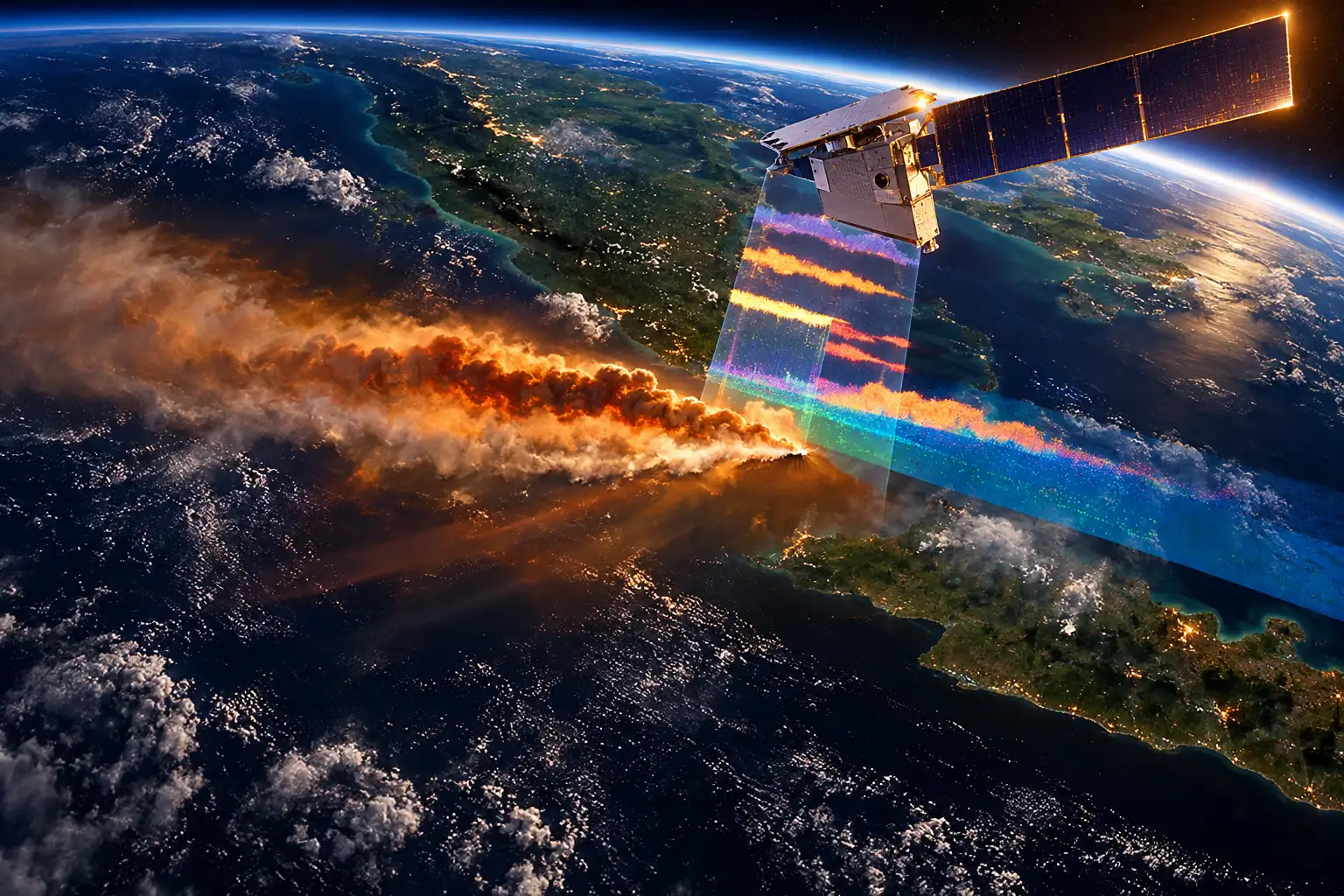
EarthCARE Cut a Vertical Slice Through the Westbound Plume
EarthCARE has been in orbit since 28 May 2024, flying near 393 km on a sun-synchronous path. Its four instruments are the atmospheric lidar ATLID, JAXA’s cloud profiling radar, a multispectral imager, and a broadband radiometer. ESA designed them to work together on clouds, aerosols and Earth’s radiation budget, not as a standing aviation sensor.
The useful pass came on the afternoon of 5 September, local time, just west of the erupting cone, close enough for ATLID to slice the westbound cloud while a VIIRS image about half an hour earlier still showed the brown ash mass. ESA’s EarthCARE account later confirmed that geometry.
ATLID transmits a 355 nm ultraviolet laser and reads the light that bounces back, from the ground up to 40 km. Algorithms then sort particle types: ash, smoke, sulphate, sea salt, desert dust. On this scene they also had to pull volcanic ash apart from wildfire smoke already in the same air, a mix ESA flagged while typing was still in progress in mid-September.
A Copernicus Sentinel-3 frame from 5 September, overlaid with EarthCARE’s imager, lidar and radar, is the picture Darwin’s forecasters could actually use. The imager swath shows the plume in false colour, purple for ash and bright green for sulphur dioxide. Above that swath, the vertical curtain is layered: optically thin and thick sulphate, fine ash, and a distinct dark brown feature treated as coarse ash.
🌋 EarthCARE’s view of Anak Krakatau plume boosts air safety 🌋
Born from the caldera of Indonesia’s infamous Krakatoa, in early September 2026 Anak Krakatau – “Child of Krakatoa” – erupted, spewing ash high into the atmosphere.
Our EarthCARE satellite passed over the eruption,… pic.twitter.com/lxKXsxu29w
— ESA's EarthCARE mission (@esa_earthcare) October 1, 2026
Large Ash Still Aloft 200 km From the Cone
Robin Hogan, at the European Centre for Medium-Range Weather Forecasts, said the radar and the lidar do not see the same grains. The radar’s much longer wavelength makes it far more sensitive to large particles and far less sensitive to small ones.
Normally we would expect the particles in a volcanic plume 200 km from the source to be too small to be detected by a radar. However, thanks to the unprecedentedly high sensitivity of the CPR, it detects a feature extending from the surface up to around 6 km (dark brown), which is believed to correspond to larger ash aggregates that are settling out of the plume.
Robin Hogan, ECMWF, ESA EarthCARE briefing
That dark brown column is the second-order fact. Aviation centres already knew not to fly through a dense plume. What they rarely get is evidence that large aggregates are still in the air 200 km downwind, from the surface up to about 6 km, in a place where textbooks say those grains should have dropped out.
If confirmed, this would provide useful evidence that large ash particles can remain aloft for longer, and travel farther, than is often assumed. The observation, therefore, offers a valuable opportunity to constrain both ash sedimentation rates and long-range transport processes in volcanic ash dispersion models.
Helen Dacre, University of Reading, ESA EarthCARE briefing
Dacre’s caution matters. Hogan’s wording is “believed to correspond,” not proven. Aggregation can make fine ash fall early, and in other eruptions it can also raft coarser cores farther than single-particle fall speeds imply. If this return is coarse ash, the next Darwin forecast and the next climate run both have a new bound. If it is something else, the grey band in the same curtain is the reminder that the typing is not finished.
Why the Grey Band Is a No-Fly Zone
ESA shaded one layer grey because ATLID’s laser cannot punch through the optically thick sulphate sitting above it, and the radar is deaf to fine ash. Nobody yet has a clean name for what sits in that gap, and ESA said it needs more study. The operational line was simpler: do not fly aircraft there.
Shannon Mason, also at ECMWF, said the layered plumes of ash, cloud, gas and aerosol from an eruption are complex and change fast. A timely EarthCARE pass let them see the vertical structure in near-real time and feed aviation advice, and scientists will keep using the measurements to watch how ash and other volcanic aerosols behave in the hours and days after an eruption.
WHAT EACH INSTRUMENT SAW
| Instrument | What it caught on this plume | Where it goes blind |
|---|---|---|
| ATLID (355 nm lidar) | Particle type and the upper westbound cap near 15 km | Laser stops in optically thick sulphate |
| CPR (94 GHz radar) | Large particles from the surface to about 6 km, 200 km from the vent | Weak on small grains |
| MSI (imager) | False-colour map, purple ash, bright green sulphur dioxide | No vertical profile of its own |
Most airliners cruise near flight level 350, which ESA puts at 35,000 ft, about 10,700 m. The westbound Anak Krakatau cloud sat near 15.2 km, above that band. The lower layers around 5.5 km and 6.1 km sat well below it, which is the air that Jakarta and Lampung approaches actually use. A satellite that only maps the top of a plume would have missed the part that closed the airports.
Darwin Locked the Westbound Plume at Flight Level 500
Nine Volcanic Ash Advisory Centres split the globe. Anak Krakatau fell to Darwin, which already runs on Himawari-9 imagery, Indonesian volcano reports, and dispersion models. What it did not have, until this pass, was a lidar curtain that types aerosols and pins the top of the cloud in the same frame as a radar that sees the heavy stuff falling out.
Andy Prata of the Bureau of Meteorology said the joint work with VAAC forecasters verified the forecast of the westward-moving plume at FL500, about 15 km. ATLID, he said, was crucial for checking the altitude of that upper-level component.
Together with the VAAC forecasters, we were able to verify the forecast guidance of the westward moving plume at FL500, which is at the altitude of around 15 km. ATLID was crucial to help forecasters verify the altitude of the upper-level component of the plume.
Andy Prata, Australian Bureau of Meteorology, ESA EarthCARE briefing
Ash can stall engines, frost cockpit windows, and send sulphur dioxide into cabin air. After the 2010 Eyjafjallajökull eruption, European airspace learned that a modest plume at the wrong height is enough to stop a network. Anak Krakatau did not match that week-long shutdown, but it did stop eight Indonesian airports until 8 September, with knock-on cancellations as far as Bali and Medan on some days.
The lidar pass did not reopen those fields. It told Darwin that the FL500 westbound call was right, and that the column was stacked, not a single blob. That is a narrower, more useful product than a colour smear on a geostationary loop.
The Climate File From the Same Volcano Family
Alex Hoffmann of ESA pointed past the NOTAMs. Major eruptions can load the stratosphere with sulphate that stays up for a long time, reflects sunlight, and cools the surface for a while. The 1883 Krakatoa eruption is the family memory on this strait.
Sulphate aerosols injected into the stratosphere by the 1883 Krakatoa eruption persisted for more than a year, reflecting incoming sunlight and causing temporary global cooling. Understanding the injection altitude of volcanic material and its optical properties is particularly important to understand climate impacts, information that EarthCARE’s lidar is well positioned to provide.
Alex Hoffmann, ESA, EarthCARE briefing
EarthCARE already had a trial on that question. After Mount Ruang erupted in North Sulawesi in April 2024, ATLID, fully working from July 2024, tracked Ruang sulphates to 25 km. A study in Atmospheric Chemistry and Physics found that those columns doubled tropical stratospheric aerosol for several months and later spread through the Southern Hemisphere.
Anak Krakatau in 2026 was a different size. NASA Earthdata’s sulphur dioxide maps put a high column over the Sunda Strait, with a centre of mass near 17 km, which is tropopause height in the deep tropics, not a Pinatubo-class stratospheric dump. The climate use of this pass is the height and the optical type, not a forecast of global cooling.
If Hogan’s dark brown column is coarse ash still 200 km out, dispersion models that drop large grains too fast will keep drawing the wrong hazard map, and climate models that assume the heavy stuff never travels will mis-count what reaches the upper troposphere. Dacre called that a chance to constrain sedimentation rates. ESA still will not name the grey band. The lidar curtain is already in Darwin’s stack; the particle-size argument is the part that outlasts the closed airports.
Frequently Asked Questions
When Was EarthCARE Launched, and Who Flies It?
A SpaceX Falcon 9 lifted EarthCARE from Vandenberg Space Force Base at 22:20 UTC on 28 May 2024. ESA runs the mission with JAXA, which built the 94 GHz Doppler cloud radar, the first of that type in orbit. The spacecraft is in a sun-synchronous orbit with a 25-day repeat cycle and a planned three-year life, including commissioning.
How Does ATLID Tell Volcanic Ash From Smoke or Dust?
ATLID is a high spectral resolution lidar. It splits the echo into Rayleigh scatter from air molecules and Mie scatter from particles, then reads polarisation. Irregular grains such as ash and desert dust depolarise strongly, often above 25 percent, while spherical droplets and many smoke particles sit much lower, often under 5 percent. JAXA lists a footprint under 32 m and vertical sampling near 100 m, which is why a single pass can type stacked layers.
What Does Flight Level 500 Mean for a Crew?
Flight levels are standard-atmosphere heights in hundreds of feet, so FL500 is 50,000 ft, the same cap Darwin logged at 15.2 km on this westbound plume. FL350, a common cruise band, is 35,000 ft, about 10,700 m. Crews never fly a flight-level number as a promise of clear air; they fly the VAAC polygon. The lidar’s job was to check that the top Darwin had written down was the top that was actually there.
How Is Anak Krakatau Tied to the 1883 Krakatoa Eruption?
The 1883 collapse left a 7 km-wide caldera in the Sunda Strait and killed more than 36,000 people, most in tsunamis that hit Sumatra and Java. Anak Krakatau, “Child of Krakatoa,” grew inside that caldera between the old Danan and Perbuwatan cones and has erupted often since 1927. The 2026 events were intense Strombolian fountaining and ash on that young cone, not a repeat of the 1883 blast.
Why Are There Nine Volcanic Ash Advisory Centres?
Ash does not show on ordinary weather radar the way rain does, and a single office cannot watch every volcano in real time. ICAO’s nine VAACs each own a region and issue the polygons airlines and air-navigation services treat as the operational product. Darwin, inside the Australian Bureau of Meteorology, owns Indonesia, which is why Himawari-9, PVMBG, and now an EarthCARE lidar curtain all feed the same desk.

Edinburgh Opens a 2027 Tour Built for Time Trials

Korda Maps Auður From Meðalland to Irvine Bay

Apple Music Films Its New Logo in Mineral Oil

Oppo Prices the Pad Mini Above India’s iPad Mini

Austen Soaks Scotland Before Boelo Brings Weekend Gales

Volkswagen Sells the Osnabruck Plant to Clear a Board Fight

Apple’s Foldable iPhone Hinges on Samsung Display Supply

Tata Motors’ Iveco Tender Opens as Holders Still Decide

Saksham Gaur Finds He Is His Own Company’s Client

Onimusha Way of the Sword Preload Hits a Windows 11 Wall
-
 AUTO2 months ago
Volkswagen Sells the Osnabruck Plant to Clear a Board Fight
-
 NEWS2 months ago
Apple’s Foldable iPhone Hinges on Samsung Display Supply
-
 AUTO2 months ago
Tata Motors’ Iveco Tender Opens as Holders Still Decide
-
 BUSINESS2 months ago
Saksham Gaur Finds He Is His Own Company’s Client
-
 GAMING2 months ago
Onimusha Way of the Sword Preload Hits a Windows 11 Wall
-

 ENTERTAINMENT3 years ago
What is SD on Amazon Prime? – All You Need to Know
-

 BUSINESS2 months ago
Hyderabad 22-Carat Gold Jumps After a False Bargain
-

 NEWS2 months ago
The Frame Pro’s $1,200 Labor Day Cut Needs a Soundbar