
 Ishan Crawford
 Google made Nano Banana 2 available inside Google Earth on the web worldwide on July 30, 2026. Zoom any location, tap create image, describe a scene, and the model builds a custom picture from the real satellite, aerial or 3D view underneath.
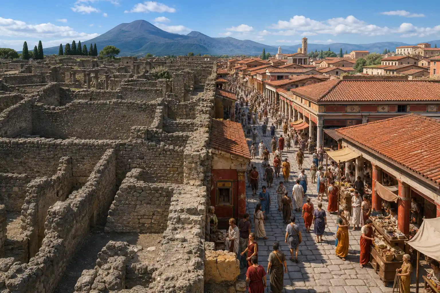
Teachers get hyper-realistic Pompeii streets. Planners get empty lots turned into retail districts. Casual users get sci-fi campuses or zombie Philly. The same power that delights also creates convincing synthetic satellite images that already worry open-source intelligence researchers.
The launch puts a consumer-facing generate button on top of imagery Google has long treated as a reference layer. That pairing is what makes the feature feel immediate and what raises the stakes when the output looks photographic.
How the Create Image Button Works
The feature lives only on the web version of Google Earth for now. No mobile apps yet. Sign in if prompted, navigate to a spot, and the toolbar shows the new control.
- Zoom or tilt until the place fills the view with satellite, aerial or 3D data.
- Tap “create image”.
- Type a plain-language prompt that tells Nano Banana 2 what to add, remove or transform.
- Wait seconds for the grounded generation; the output stays inside your project and carries a SynthID watermark.
Google product manager Bryan Horowitz framed it as the first time users can generate custom images that stay tied to Earth’s real imagery. The model does not rewrite the live map. It produces a separate picture.
That separation matters for everyday use. Users can iterate on prompts without fear of damaging the basemap, and the generated frame remains a project asset rather than a permanent edit. The tradeoff is that the control never appears in Street View, so house-level work must run from lower-fidelity satellite or 3D tilts.
Grounded generation still begins from whatever geometry and pixels fill the current viewport. The prompt then steers what the model adds, removes or restyles. Seconds later the result appears with its watermark already embedded.
The Model Under the Hood
Nano Banana 2 is Gemini 3.1 Flash Image, launched February 26, 2026. It brings Pro-level world knowledge and subject consistency to Flash speed.
- World knowledge: pulls real-time web search and Gemini’s knowledge base for landmarks and facts.
- Consistency: holds up to five characters and fourteen objects across a workflow.
- Specs: aspect ratios and resolutions from 512px to 4K.
- Provenance: every image gets SynthID digital watermarking plus C2PA credentials.
It already powers Gemini app defaults, Search AI Mode, Flow, Ads and the API. The Earth integration is the newest surface. Full Nano Banana 2 model specs and rollout sit on Google’s DeepMind blog.
The same model family therefore shows up in chat, search, creative tools and now a planetary viewer. Earth simply supplies a geolocated starting frame instead of an empty canvas or an uploaded photo.
- February 26, 2026: Nano Banana 2 launches as Gemini 3.1 Flash Image with world knowledge, multi-subject consistency and SynthID plus C2PA provenance.
- July 30, 2026: The create image control reaches Google Earth on the web worldwide, tying that model to live satellite, aerial and 3D views.
Five Pitches Google Made Public
The official post lists concrete starting points. Each begins from a real Earth view.
| Use case | Example prompt style | Intended user |
|---|---|---|
| Bring history to life | Render hyper-realistic Pompeii ruins as 78 A.D. street | Teachers, students |
| Custom infographics | Easy infographic of Statue of Liberty with key facts | Learners, tourists |
| Real estate plans | Empty Tokyo lot as vibrant shopping district | Architects, developers |
| Pre-build visualization | Add modern lakefront cabin of local materials | Homeowners, planners |
| Playful makeover | Mountain View campus as sci-fi utopia with biodomes | Anyone |
Google walks through the five ways to try image generation with video demos. The grounding claim is that the model starts from the actual geometry and imagery rather than a blank canvas.
Those five pitches share one pattern: the viewport supplies place, and the prompt supplies intent. History, commerce, housing and pure play all reuse the same button. Only the language in the prompt box changes.
What Early Hands-On Tests Produced
ZDNET senior editor David Gewirtz received pre-release access and ran real locations. The results were mixed in a revealing way.
Architectural tests often failed to isolate the correct house or spilled changes onto neighbors. Historical prompts for Independence Hall in 1776, 1876 and 1976 missed or resized known buildings such as the Public Ledger structure that stood on the corner. Infographic requests rearranged Philadelphia streets and produced garbled text labels. Futuristic and absurd prompts (steampunk gears, cheerful zombie clowns, alien mechs) looked more coherent because they needed less factual fidelity.
| Prompt category | What early tests showed |
|---|---|
| Architectural isolation | Failed to isolate the correct house; changes spilled onto neighbors |
| Historical rebuilds | Missed or resized known structures such as the Public Ledger building |
| Infographics | Rearranged Philadelphia streets and produced garbled text labels |
| Futuristic and absurd scenes | Steampunk gears, zombie clowns and alien mechs looked more coherent |
Rather than work with deep knowledge of the environment portrayed on the Google Earth screen, it works as if Google Earth simply passes it a screenshot and a prompt.
Gewirtz wrote that summary after the Independence Hall series. The Create Image control also fails to appear in Street View, forcing users into lower-fidelity satellite tilts for house-level work. Fun succeeds. Precise geographic work does not yet.
The gap is consistent across the test set. When the prompt demands exact period buildings or clean street labels, errors appear quickly. When the prompt invites spectacle, the same pipeline produces images that feel finished.
Trust, Watermarks and the OSINT Worry
Google answered misinformation concerns the same day. Every Earth Nano Banana image carries SynthID. Users can check it in the Gemini app or via Lens in Search. The company also blocks harmful topics and updates protections continuously.
What we know
- Images are watermarked and do not alter the live Earth basemap.
- Outputs stay inside projects; no direct public export button was highlighted at launch.
- Google Earth posted a public #goBananas challenge inviting playful creations.
What’s unconfirmed
- Exact mobile timeline or Street View support.
- How robust the watermark remains after screenshots or third-party edits.
- Whether deeper geo-database grounding arrives in later iterations.
On X, OSINT voices immediately flagged the risk. Synthetic satellite photos that look real enough can poison geolocation workflows that rely on matching terrain and structures. One researcher noted maps themselves become less reliable reference material once anyone can mint photorealistic fakes of any coordinates in seconds. Google’s watermark defense is real; visible, universal detection is still the open request.
The irony sits right there. The feature that lets a teacher show Pompeii alive also lets anyone mint a fake aerial of a contested border or a staged disaster site.
Project-only storage and the missing public export button slow casual leakage. They do not stop a determined user from capturing the frame. That is why watermark durability after screenshots remains the unresolved piece for researchers who treat imagery as evidence.
Where This Sits Inside Google’s Larger Earth AI Push
Consumer image generation is the visible tip. Underneath, Google has spent years on geospatial foundation models for floods, wildfires, air quality, cyclones and land cover. Flood Hub alone covers river basins serving hundreds of millions. Imagery models now accept natural-language queries to find objects or change across satellite archives. Partners including Planet, Airbus, Deloitte and humanitarian groups already run production workloads on those systems.
The Google Earth AI geospatial models page frames the stack as turning planetary data into actionable intelligence in minutes. Nano Banana 2 in the consumer Earth client is the playful entry point to the same imagery and reasoning stack. Casual users get fun. Enterprises get object detection and risk maps.
The consumer button and the enterprise pipelines share imagery sources and reasoning habits even when their outputs look nothing alike. One path ends in a biodome campus. The other ends in a flood footprint or a land-cover change map. Both start from the planet as data.
Who Gains Right Now and Who Waits
Immediate winners are clear.
- Classroom teachers who need a 30-second visual hook for a history unit.
- Real-estate agents and small developers who want client-ready concept art without a full rendering budget.
- Curious explorers who simply want to see their street as a cyberpunk strip or pet resort.
- Google itself, which keeps Nano Banana sticky across more surfaces and gathers fresh prompt data.
Professionals who need measurement-grade accuracy, consistent historical reconstruction or court-ready visuals still reach for dedicated tools or straight Gemini with Street View pastes. Early testers found the Earth version more entertaining accessory than replacement. That gap is the product’s current shape, not a secret.
Availability is global on web today. The next useful upgrades are obvious: Street View support, tighter historical data hooks, mobile, and clearer export paths that keep the watermark intact. Until then the button delivers exactly what the demos promise and exactly what the stress tests revealed.
Teachers and agents can ship a visual in the time it takes to type a sentence. Surveyors, litigators and restoration architects still need tools that lock geometry and provenance to a higher standard. The product serves the first group now and leaves the second group waiting on later iterations.
Fun Prompts Outperform Strict Geographic Rebuilds
The hands-on pattern and the five official pitches line up more tightly than they first appear. Google’s public examples lean on atmosphere, concept art and light factual overlay. The stress tests punish exactly the prompts that demand measured fidelity.
Loose creative direction gives the model room to invent surfaces, lighting and props. Strict rebuilds require the model to know which building stood on which corner in which decade and to keep neighboring roofs untouched. When that knowledge is thin, the output drifts.
Infographic attempts sit in the middle. They need both place and readable text. Early runs rearranged streets and garbled labels, showing that dual demand still strains the pipeline.
- Playful makeovers and sci-fi campuses match the model’s strength in coherent spectacle.
- Pre-build cabin concepts work when the goal is mood rather than permit-ready plans.
- Period street reconstructions and precise house isolation expose the current limits of grounding depth.
Users who treat the button as a concept sketch tool leave happier than users who treat it as a historical or cadastral instrument. That reading follows directly from the demos Google chose and the failures Gewirtz recorded.
Watermark Checks Still Leave an Open Detection Gap
SynthID and C2PA credentials travel with every Earth Nano Banana image. Verification paths already exist inside the Gemini app and via Lens in Search. Those mechanisms answer the basic question of origin when the file remains intact.
OSINT concern focuses on the next step. Once an image is screenshotted, re-encoded or dropped into a third-party editor, the practical question becomes whether a field analyst can still spot the synthetic origin at a glance. That visible, universal detection layer is the request Google has not closed.
The launch posture is therefore layered rather than absolute. Harmful-topic blocks reduce some abuse classes. Project-scoped storage reduces casual redistribution. Watermarks provide a cryptographic trail when the container survives. None of those controls fully answers a workflow that only ever sees a flattened photograph of a contested coordinate.
Until detection is as portable as the pixels, researchers will keep treating photorealistic aerials of sensitive sites as a new contamination risk. The same button that fills a classroom screen can still mint reference material that looks official enough to mislead a hurried match.
Frequently Asked Questions
How do I start generating images with Nano Banana 2 in Google Earth?
Open earth.google.com in a browser, zoom to any location until the satellite or 3D view is clear, tap the create image control in the toolbar, type a descriptive prompt, and generate. The feature requires the web client; native mobile apps do not include it at launch.
What exactly is Nano Banana 2?
It is Google’s Gemini 3.1 Flash Image model, released in February 2026. It combines fast generation with advanced world knowledge from web search, subject consistency across multiple characters and objects, text rendering, and output resolutions up to 4K while remaining cheaper and quicker than the Pro variant.
Do the generated images change the actual Google Earth map?
No. The tool produces a separate AI image grounded in the current view. The live basemap, historical imagery layers and 3D buildings remain untouched. Outputs live inside user projects and carry invisible SynthID watermarks for later verification.
Is Nano Banana image generation free in Google Earth?
Yes for standard Google Earth web users at launch. No credit cost or subscription gate was announced for the create-image feature itself. Enterprise or API use of the underlying model follows separate Gemini pricing.
Can I use the feature on mobile phones or tablets?
Not yet. The July 30, 2026 rollout is limited to the Google Earth web experience. Google has not published a mobile timeline, though the underlying Nano Banana 2 model already runs inside the Gemini mobile app for other image tasks.
 Scotland’s Facial Recognition Push Sparks Mask Ban Call
  Galaxy Z Flip 8 Hits $799 Only If Your Trade-In Qualifies
  If England Had Kept Water Public Like Scotland
  Samsung Smart Switch Now Moves Passwords and eSIM From iPhone
  Old Firm Spend Pulls Clear as Premiership Rivals Patch Squads
  Chinese Studios Quietly Seize the Gamescom Stage