
 Ishan Crawford
 Beneath a small stone island in a freshwater loch on Scotland’s Isle of Lewis sits a wooden platform that people built more than 5,000 years ago, before the first stones of Stonehenge were hauled into place. Archaeologists at the University of Southampton, working with the University of Reading, have now recorded that artificial island, known as a crannog, as one continuous structure from the loch bed to the open air. It is the most complete picture yet of a site that has puzzled fieldworkers for years.
The age is the part that travels. Less obvious, and arguably more useful, is the surveying trick the team had to invent to see the island at all, because it solves a problem that has kept most of Scotland’s submerged heritage out of focus.
What Lies Beneath the Stone Cap
The crannog sits in Loch Bhorgastail, a small body of water in the Outer Hebrides. From the surface it reads as a rough mound of stone. Underneath, the Southampton and Reading teams found layers of timber and brushwood, the original engineering that the later stone covering had hidden for millennia.
The dating did not come from the wood alone. Scattered in the water around the islet were hundreds of fragments of Neolithic pottery, pieces of different jars and bowls, which anchor the first construction to the Neolithic period between 3800 and 3300 BC. That timeline fits a 2019 reassessment that pushed Hebridean crannog origins back into the Neolithic, overturning the old assumption that these islands were largely Iron Age and medieval.
The site was not built once and abandoned. It grew in distinct bursts, separated by centuries, with each generation adding to what was already there.
| Phase | Approximate period | What was added |
|---|---|---|
| Original platform | Neolithic, 3800 to 3300 BC | Circular timber platform about 23 metres wide, topped with brushwood |
| Second build | Middle Bronze Age, around 2,000 years later | A further layer of brushwood and stone over the older base |
| Final activity | Iron Age, roughly 1,000 years after that | Renewed use, with a submerged stone causeway linking the island to the shore |
Why Neolithic People Sank Islands Into Lochs
Nobody knows for certain why early farming communities chose to build in open water rather than on dry land a short walk away. What the evidence does show is effort. A platform 23 metres across, cut timber, brushwood and later stone, all moved into a loch, points to organised labour and a reason that mattered to the people doing the work.
The pottery offers a clue. Much of it appears to have been placed into the water on purpose rather than dropped by accident, and chemical study of similar vessels has found lipid traces of cereals, milk and meat inside crannog pottery. That points to cooking and eating on or around the islands, the kind of communal gathering that turns a structure into a meeting place.
Stephanie Blankshein, an archaeologist at the University of Southampton and lead author of the new study, frames the labour as a signal of how much these places mattered.
While we still don’t know exactly why these islands were built, the resources and labor required to construct them suggests, not only complex communities capable of such feats, but also the great significance of these sites.
That reading places crannogs alongside other large Neolithic projects that demanded coordinated muscle, from the standing stones of the same era to feats of transport on the other side of the world, such as how Easter Islanders walked their multi-ton moai statues across the island. The deliberate deposits also echo the careful, symbolic handling of objects seen at ritual sites like the 7,500-year-old Neolithic deer-skull headdress found in Germany.
The White Ribbon That Defeats Surveyors
Here is the technical knot the team had to untie. The crannog straddles a zone archaeologists grimly call the white ribbon, the strip running from the dry shore down through ankle-deep water to about a metre of depth. Land survey gear stops at the waterline. Underwater photogrammetry, the workhorse of marine archaeology, performs well in deep, clear water but falls apart in the shallows.
Fine sediments, choppy conditions, floating vegetation, and distorted or reflected light all hinder shallow water imaging.
That is Fraser Sturt, principal investigator and director of the Southampton Marine and Maritime Institute, describing the conditions. Because photogrammetry struggles below a metre of depth, the very band where a crannog meets its loch has long been the hardest part of the site to record, leaving every survey with a blank seam down its middle.
How a Two-Camera Rig Reads the Loch Bed
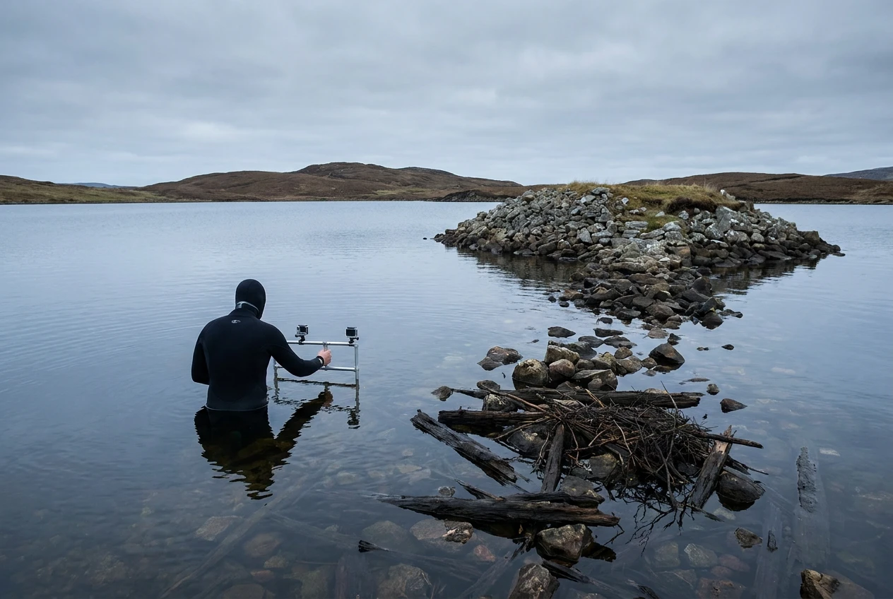
The fix, developed and tested during fieldwork in 2021, is deliberately low-cost. Stereophotogrammetry (a method that builds a 3D digital model from overlapping photos taken by two fixed cameras) gave the team a way to keep capturing accurate shapes even when the water spoiled half the data. A diver swam the rig across the loch bed while satellite positioning tracked it to within centimetres, matching the precision a drone manages in the air.
The kit list reads more like a weekend dive setup than a research budget, which is the point. The full shallow-water imaging workflow published in Advances in Archaeological Practice lays out the components and the accuracy each one delivered.
- Two GoPro Hero 9 cameras, fixed 29 centimetres apart on a frame to create a stereo pair that compensates for missing or distorted images
- Plus or minus 3 millimetres of internal accuracy, fine enough for close-range 1:20 recording standards
- Plus or minus 60 millimetres of external accuracy once georeferenced, in line with broader site mapping
- Real-time kinematic satellite positioning (RTK-GNSS) and drone marker rods to stitch the underwater and aerial data into one model
The result is a single 3D model that crosses the waterline without a gap, the view that neither a land survey nor a dive survey could produce on its own. It is the first published output from Southampton’s new Coastal and Inland Waters Heritage Science Facility.
Hundreds of Crannogs Still Off the Map
This is where the method outgrows the single island. There are hundreds of crannogs in the lochs of Scotland, and by the team’s own account many remain unexplored or never recorded at all. The barrier has rarely been a lack of interest. It has been the cost and difficulty of imaging structures that sit half in and half out of murky, shallow water.
A portable, repeatable rig built around consumer cameras changes that arithmetic. Surveying that once needed expensive marine equipment and ideal conditions can now, in principle, be done by a small team with a frame and a diver, the same way a student dig in the Northern Isles can still surface major finds such as a 900-year-old Viking-era stone head on the island of Rousay. The Loch Bhorgastail fieldwork was backed by an Arts and Humanities Research Council grant, and the team hopes the technique can carry into future investigations of similar sites.
So the headline find dates to the Stone Age, but the development with the longest reach is the tool itself. If the rig travels as well as its makers expect, the number of properly recorded crannogs could climb faster in the coming decade than it has in the past century.
Frequently Asked Questions
What Is a Crannog?
A crannog is a small artificial island built in a loch, river or estuary, usually from timber, brushwood and stone, and often linked to the shore by a causeway. Hundreds survive in Scotland, and they were used and reused across thousands of years for settlement, gathering and ritual deposition.
How Old Is the Loch Bhorgastail Crannog, and Is It Really Older Than Stonehenge?
Yes. The original timber platform was built more than 5,000 years ago, in the Neolithic period between 3800 and 3300 BC, which predates the main stone-building phases at Stonehenge. Later communities added to it during the Middle Bronze Age and the Iron Age.
Where Is Loch Bhorgastail?
Loch Bhorgastail is a small freshwater loch on the Isle of Lewis in the Outer Hebrides, off the northwest coast of Scotland. The region holds several crannogs that have produced Neolithic material.
What Is Stereophotogrammetry and Why Is Shallow Water Hard to Image?
Stereophotogrammetry builds a 3D model from overlapping photographs taken by two cameras fixed a set distance apart. Shallow water is difficult because fine sediment, choppy surfaces, floating plants and reflected light distort the images, and standard photogrammetry tends to fail at depths under one metre.
Why Did Neolithic People Build Artificial Islands?
The exact reason is still unknown, but the labour involved suggests the sites carried real significance. Large quantities of pottery, some still holding food residue, point to communal use such as cooking and feasting, and much of the pottery seems to have been placed into the water deliberately.
How Many Crannogs Are There in Scotland?
Hundreds of crannogs exist in Scottish lochs, and many have never been explored or formally recorded. That is why a low-cost, portable surveying method matters, since it lowers the barrier to studying sites that were previously too difficult or expensive to map.
 ONGC licence frees Venezuela cash and operatorship talks
  Anthropic Hits $65 Billion Run Rate and Flips the AI Cash Test
  Supreme Court grounds the fare free-for-all with three-week clock
  Gold Nears $4400 as Soft Data Meets Oil Inflation Risk
  Nifty Slips as Zaggle Circuits and Dhoot Debuts Big
  Diesel Crack Tops $100 as Iran Rhetoric Lifts Crude