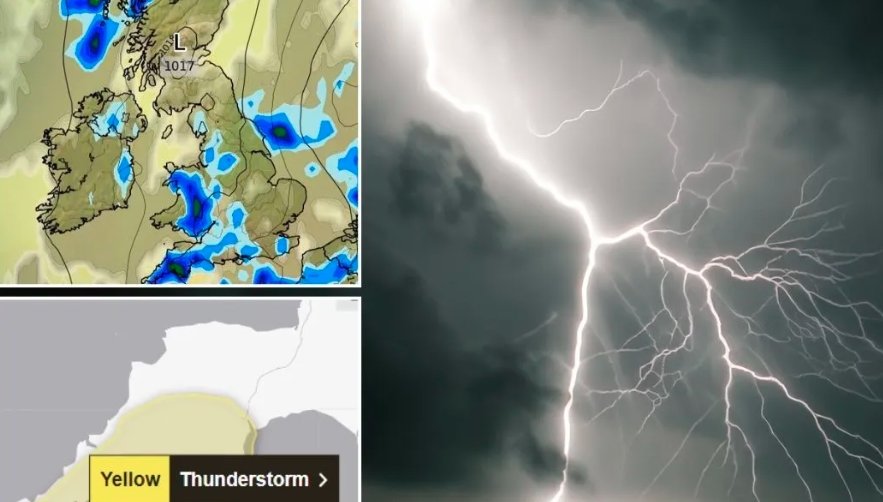
Scotland woke up to sweltering heat and an urgent double weather alert on Thursday, with the Met Office warning of thunderstorms capable of dumping dangerous amounts of rain in a very short time.
The national forecaster says some spots could be lashed by as much as 60mm of rain in an hour — the kind of intense downpour that turns streets into rivers and brings travel to a standstill.
Storm Risk Spreads Across the Country
This isn’t a localised pocket of bad weather. From the Borders to the Highlands, the yellow thunderstorm warning stretches across the map. The alerts came into effect at midnight and will stay in place until 10pm, covering nearly every community.
Most areas may get away with staying dry, forecasters stress. But the gamble is that anywhere in the zone could be hit without much warning. One village might see blazing sunshine while the next gets pounded with hail, lightning, and torrential rain.
And it’s not just a gentle summer shower we’re talking about. Some of these storms will hit hard and fast. Central and eastern regions have the highest odds of catching the brunt, though coastal ferry towns and inland road networks are also on edge.
Travel Disruption on the Cards
The speed and ferocity of the rain could quickly overwhelm drains and ditches, leading to surface water flooding. That means roads could go from passable to dangerous within minutes.
Rail operators are on alert for flash flooding on tracks and potential signalling faults caused by lightning strikes. Ferry routes may also face cancellations or delays if winds strengthen.
Road safety groups are urging drivers to plan journeys with caution. Sudden standing water can cause cars to hydroplane, and visibility drops sharply when rain is that heavy.
Some key trouble points officials are watching:
-
Low-lying rural roads with poor drainage
-
City underpasses prone to pooling water
-
Railway cuttings in flood-sensitive corridors
Heatwave Adds to the Strain
In an odd twist, the storms are arriving at the height of an unseasonably strong heatwave. Temperatures have soared into the high 20s Celsius in many places — a rare figure for Scotland in mid-August.
That hot, humid air is basically rocket fuel for thunderstorms. The warmth helps lift air rapidly into the atmosphere, where it cools and condenses into massive storm clouds.
The combination of heat and incoming rain means the air feels heavy and sticky — not the kind of weather most Scots are used to. For those without air conditioning, Thursday could feel almost tropical indoors.
What the Numbers Say
While weather forecasts always carry uncertainty, the Met Office’s warning language is unusually blunt this time. Here’s how the rainfall potential looks based on their models:
| Expected Rainfall | Timeframe | Impact Level |
|---|---|---|
| Up to 20mm | Under 30 mins | Minor |
| 40mm | Under 1 hour | Moderate – risk of flooding in prone spots |
| 60mm | Under 1 hour | Severe – high likelihood of flash flooding |
Those higher-end figures are rare for the UK outside of extreme weather events. For context, 60mm in an hour is roughly what Glasgow might expect across an entire summer month in a typical year.
Emergency Services on Alert
Local councils and emergency responders are on standby. Crews have been checking flood barriers, clearing debris from gullies, and positioning sandbags in flood-prone streets.
In some towns, community volunteers are already distributing advice leaflets and posting updates on social media, warning people to move cars from low spots and keep an eye on weather radar apps.
One firefighter in Perthshire put it bluntly: “If you see water covering the road, don’t chance it. You don’t know what’s under there — could be a hole, could be a live cable.”
Evening Easing Expected — But Not Guaranteed
The good news, if it holds, is that forecasters think the storms will lose their punch by mid to late evening. As the heat drops and the atmosphere stabilises, showers should taper off.
But given the unpredictable nature of convective storms, no one’s making promises. It’s entirely possible a rogue cell could linger longer than expected, keeping parts of the country wet into the night.
For now, the advice is simple: check the forecast, keep plans flexible, and don’t assume dry skies will last.