Storm Amy, the first named storm of the 2025 season, has been upgraded to an amber warning by the Met Office for strong winds battering north and west Scotland as well as parts of Northern Ireland. This escalation comes as the storm barrels toward the UK, promising gusts up to 95 miles per hour and heavy rain that could disrupt travel and daily life starting Friday evening.
Storm Amy: An Early Season Powerhouse
Experts describe Storm Amy as a potent weather event for so early in autumn. It formed from a deepening low pressure system over the Atlantic, pulling in moist air that fuels both fierce winds and downpours. The Met Office named it Amy on Thursday, marking the start of the storm season that runs from September to March.
This storm stands out because it arrives just as leaves begin to fall, making trees more vulnerable to toppling in high winds. Forecasters note that while named storms are common, one this intense in early October feels unusual and could set the tone for a wet and windy winter ahead. Recent climate patterns suggest warmer Atlantic waters are contributing to stronger early storms, linking this event to broader trends in global weather shifts.
Details of the Weather Warnings
The amber wind warning covers large swaths of north and west Scotland, including Argyll, the Highlands and Islands, Moray, and Orkney. It activates from 5pm on Friday, October 3, until 9am on Saturday, October 4. Within this zone, expect widespread gusts of 60 to 70 miles per hour, with exposed coastal spots facing blasts over 95 miles per hour.
A broader yellow wind warning applies to all of Scotland, Northern Ireland, and much of north and west England and Wales. This runs from 3pm Friday to midnight Saturday, forecasting gusts up to 60 miles per hour generally and 70 in open areas. Additionally, a yellow rain warning targets Scotland and Northern Ireland, predicting 20 to 30 millimeters of rain in six to nine hours, with up to 40 to 50 millimeters possible in hilly regions of southwest Scotland and the southern Highlands.
To summarize the warnings clearly:
| Warning Type | Areas Affected | Time Period | Expected Conditions |
|---|---|---|---|
| Amber Wind | North and west Scotland (Argyll, Highlands, Islands, Moray, Orkney); Parts of Northern Ireland (Antrim, Fermanagh, Derry, Tyrone) | 5pm Fri Oct 3 to 9am Sat Oct 4 | Gusts 60-70 mph widespread; up to 95+ mph in exposed areas; potential damage to structures |
| Yellow Wind | All Scotland, Northern Ireland, north/west England and Wales | 3pm Fri Oct 3 to midnight Sat Oct 4 | Gusts up to 60 mph; 70 mph in exposed spots; travel disruptions likely |
| Yellow Rain | Scotland and Northern Ireland | Various periods Fri-Sat | 20-30 mm rain; 40-50 mm in hills; risk of flooding |
These alerts highlight the storm’s dual threat of wind and water, urging residents to stay informed through official channels.
Potential Impacts and Disruptions
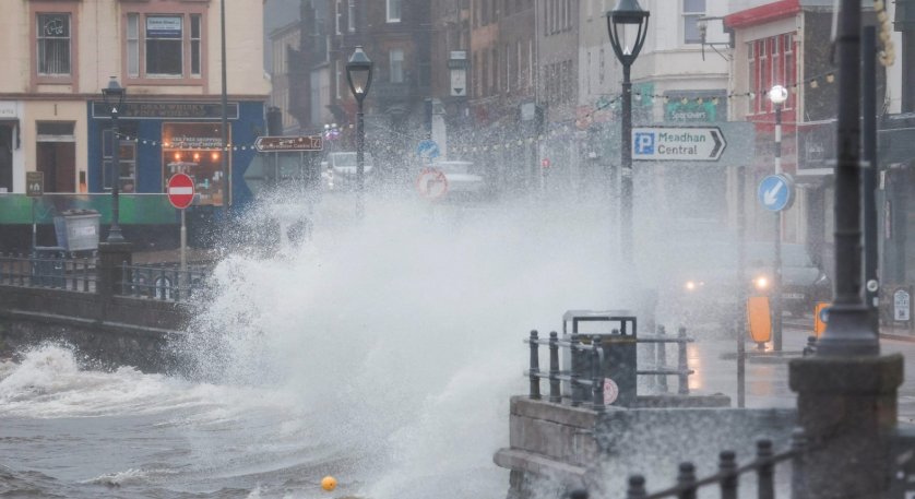
Storm Amy could wreak havoc similar to past events, with risks of fallen trees, power outages, and flooded roads. In Scotland, strong winds from January’s Storm Éowyn already caused widespread damage, including a red danger to life warning over the central belt and southwest. This time, early reports show road and rail services bracing for delays, with some lines potentially closing overnight.
Airports like Glasgow and Aberdeen advise passengers to check flight statuses, as gusts may ground planes or cause diversions. In Northern Ireland, the new amber warning for counties like Antrim and Fermanagh raises concerns for coastal communities, where waves could reach dangerous heights. Events are feeling the pinch too; the junior and mini races of the Great Scottish Run in Glasgow have been cancelled to ensure safety.
Here are key expected impacts:
- Power cuts affecting thousands, especially in rural areas with overhead lines.
- Travel chaos, including ferry cancellations to islands like Orkney and possible motorway closures.
- Flooding in low-lying spots, with alerts already issued for Argyll and Bute.
- Structural damage, such as roofs lifted or debris scattered in urban centers.
These disruptions come at a busy time, with weekend plans across the UK now in jeopardy, reminding everyone of the storm’s practical toll on everyday routines.
How to Prepare for Storm Amy
Preparation can make all the difference when facing a storm like Amy. Start by securing outdoor items like garden furniture or bins to prevent them from becoming projectiles in the wind. Stock up on essentials such as torches, batteries, and non-perishable food in case power fails, which experts say could last hours or days in severe cases.
For those in warning areas, consider trimming loose branches around your home now, as leafy trees are extra susceptible. If driving, avoid exposed roads and bridges where crosswinds pose risks. Coastal dwellers should steer clear of beaches due to large waves and possible storm surges. Following the recent power cut guidance from utilities, keep mobile phones charged and have alternative heating sources ready if needed.
Remember, the Met Office emphasizes staying indoors during peak winds from Friday evening through early Saturday. This proactive approach not only protects property but also saves lives, drawing from lessons learned in previous storms.
Looking Ahead: Winds Shift North
As Storm Amy peaks overnight Friday into Saturday, the strongest gusts will ease in most areas by midday Saturday, giving way to blustery showers and sunny spells. However, the Northern Isles, including Orkney and Shetland, may see lingering winds of 70 to 75 miles per hour into Sunday. Elsewhere, calmer conditions return, though scattered heavy showers with hail remain possible.
This storm underscores the unpredictable nature of UK weather, especially with climate influences making seasons more extreme. Forecasters predict a mixed weekend after Amy passes, but residents should monitor updates for any extensions to warnings. By sharing your experiences in the comments below and spreading awareness on social media, you can help keep your community safe during this turbulent start to autumn.
 Coal India, BEL Miss Estimates as India’s Mid-Caps Surge Ahead
  HCLTech’s Neo.AI Unit Chases the Business Its Mid-Tier Rivals Built
  Nvidia in Talks to Guarantee $250 Billion for OpenAI’s Data Hub
  HDFC Bank Fines CEO and CFO, Refers MSRDC Case to RBI
  Hyderabad Gold Rate Rises as India’s New 15% Duty Bites
  Maruti Brezza Facelift Prices Fall Thanks to a Tax Rule