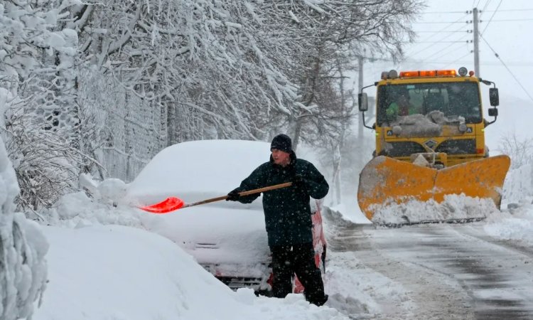
A powerful winter storm will strike Scotland on November 13, bringing heavy snow and freezing temperatures that could disrupt daily life across the northern UK. This event, driven by cold Arctic air, threatens areas like Inverness and Aberdeen with up to 3 centimeters of snow per hour, while northern England faces lighter flurries.
Snowstorm Targets Northern Scotland
Weather models show the storm arriving between midnight and 6 AM on November 13. Snow will fall heavily in key spots such as Inverness, Wick, and Aberdeen, with rates reaching 3 cm per hour. Accumulation could hit 3 to 4 cm in these regions, creating slippery roads and low visibility.
Local teams are gearing up for the impact. They plan to grit main routes and monitor high ground where snow might pile up faster. This early winter blast reminds many of past events like the Beast from the East in 2018, which brought similar chaos but lasted longer.
Experts note that a weak La Nina pattern this season boosts chances for such cold snaps. While not as severe as that historic freeze, the timing in mid November could catch people off guard as they adjust from milder fall weather.
Lighter Snow in Southern Scotland and Northern England
Southern parts of Scotland and areas around Newcastle and the Pennines will see sleet or light snow. Amounts here stay under 2 cm, but higher elevations could get more. Temperatures will drop to near freezing, making any moisture turn icy quickly.
Travelers in these zones should watch for black ice on untreated roads. Recent patterns show that even small snowfalls can halt buses and trains if winds pick up. One logical concern is how this ties into broader UK trends, where November often sees a shift to wintry mixes after wet spells.
Communities in the Borders might feel the chill most at night, with lows dipping to minus 2 degrees Celsius. This setup allows for frost to form easily, adding to driving risks.
Dry but Chilly Conditions in Central and Southern England
Central and southern England, including Manchester, Birmingham, and London, will avoid the snow but face cold air. Expect dry days with highs around 5 to 7 degrees Celsius and gusty winds near coasts. Coastal showers could bring sleet, but nothing heavy.
Residents here might enjoy clearer skies compared to the north. However, the overall drop in temperatures signals the start of a colder phase through late November. This contrast highlights how storms like this one funnel cold air southward without full precipitation.
For those in urban areas, the practical worry is heating bills rising with the chill. Recent energy price updates make staying warm a timely issue for many households.
Rain and Wind in Northern Ireland and Wales
Northern Ireland and Wales will dodge the snow but deal with rain showers and stronger winds. Localized flooding risks rise in hilly spots, where runoff from earlier rains lingers. Temperatures hold milder at 8 to 10 degrees Celsius, but wet roads pose slip hazards.
This weather fits a pattern of Atlantic influences dominating the UK’s west side. Flash flood warnings could come into play if downpours intensify overnight. Outdoor plans, like weekend hikes, need rethinking to avoid soaked gear and chilled bones.
Authorities advise checking river levels, as similar events last year led to road closures in rural Wales.
Travel and Tourism Disruptions Ahead
The storm promises big headaches for travelers. Icy roads in Scotland could delay flights at airports like Inverness and cause train cancellations. Northern England routes might see similar issues, with drivers urged to carry winter kits.
Tourism takes a hit too, especially in the Highlands where visitors flock for scenic drives. Winter sports fans might welcome the snow for early skiing, but access roads remain a problem. Airlines report possible diversions, echoing disruptions from Storm Bert in late 2024.
To help plan, here is a table of expected snow accumulation by region:
| Region | Expected Snow Depth (cm) | Risk Level |
|---|---|---|
| Northern Scotland (Inverness, Wick, Aberdeen) | 3-4 | High |
| Southern Scotland (Borders) | 1-2 | Medium |
| Northern England (Pennines, Newcastle) | 0-1 (sleet) | Low |
| Central/Southern England | None | None |
| Northern Ireland/Wales | None (rain) | Low |
Key affected areas include:
- Inverness: Heavy snow, flight delays likely.
- Aberdeen: Road closures on rural paths.
- Pennines: Icy hills for motorists.
- London: Minimal impact, but colder commutes.
This storm underscores the need for better infrastructure resilience, as climate shifts bring more variable weather. Recent upgrades to gritting fleets in Scotland show progress, but rural spots still lag.
Stay safe by monitoring updates and preparing essentials like blankets and charged phones. Share your thoughts on this winter preview in the comments below, and pass this article along to friends planning UK trips.
 One UI 9’s Privacy Display Fix Reaches Just One Galaxy Phone
  Samsung Drops Its Own Exynos Chip for the Galaxy Watch9 and Ultra 2
  Marathon’s Vault Breaker Arrives as Bungie’s Bigger Bet Keeps Faltering
  Sony’s PlayStation Disc Cutoff Erases the Last Proof of Ownership
  Tesla’s Summer Update Hands Grok the Keys, and Musk’s Empire More Reach
  Apple’s $634 Million Masimo Payment Is Final After Appeal Denial