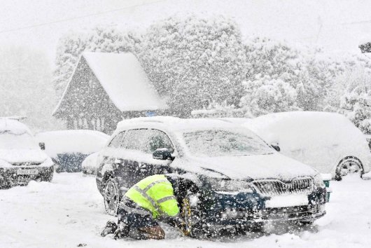
A fierce storm is set to slam the UK and parts of Europe with heavy snowfall, freezing winds, and severe travel disruptions. The latest weather models indicate that winter will make an unexpected return, bringing hazardous conditions across multiple countries.
Snowfall Expected Across the UK
Forecasters warn that snow could begin falling as early as 6 a.m. on Friday, 28 March. The worst-hit areas are expected to be in Scotland, while England and Wales will face widespread rain.
By Saturday, 29 March, the situation will intensify:
- Temperatures will plummet, with wind chills making much of the UK feel like 0°C or lower.
- Northern England could see moderate snowfall, with accumulation rates reaching 2cm per hour.
- Wales and southern England are expected to stay above freezing but will endure heavy rain and strong winds.
European Countries on Alert
The impact of this storm won’t be confined to the UK. France, Germany, the Netherlands, and Ireland are also bracing for turbulent weather.
A breakdown of expected conditions:
| Country | Expected Impact |
|---|---|
| UK | Snow in Scotland, rain elsewhere |
| France | Heavy rain, strong winds |
| Germany | Freezing temperatures, rain |
| Netherlands | Coastal flooding risk |
| Ireland | Strong winds, heavy showers |
Travel Disruptions and Safety Warnings
Authorities are urging travelers to check for delays and cancellations, particularly for flights, trains, and road travel. The Met Office has issued warnings for icy conditions and reduced visibility in affected regions.
By Sunday, 30 March, conditions may slightly improve, but isolated snowfall could linger in North Yorkshire, while wet and windy weather persists elsewhere.
With temperatures plunging and snow sweeping across key regions, the return of winter is set to cause havoc for millions across Europe.