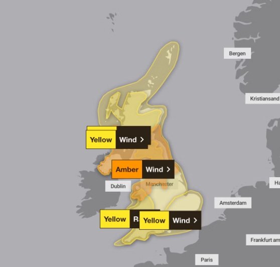
A fierce weather system is on its way, and it’s called Storm Éowyn. The Met Office has issued yellow warnings, signaling strong winds across much of the country this Friday and Saturday. Disruptions to travel, power outages, and potential damage to property are all on the table as this storm approaches Scotland from the south.
What the Yellow Warning Means
A yellow warning might sound less serious, but it’s a signal to prepare. It covers a broad range of potential impacts, and it’s all about timing. Starting Friday morning, winds will sweep in from the south, intensifying as they travel further north into Scotland.
The key takeaway? It’s not just about gusts. Sustained high winds over several hours can cause more issues than a brief storm burst. Expect possible road closures and transport delays as authorities prioritize safety.
The Met Office’s warning system has three levels—yellow, amber, and red. Yellow is the first step and often serves as a heads-up to stay alert:
- Travel Delays: Roads and bridges might close if winds are too strong. Check for updates before heading out.
- Power Cuts: High winds can topple trees onto power lines, causing blackouts in affected areas.
- Structural Damage: Roof tiles, fences, and even scaffolding could become casualties if winds reach forecasted speeds.

Commuter Chaos Likely
For those who rely on Scotland’s rail network, prepare for a bumpy ride—literally and figuratively. Strong winds have a knack for disrupting train schedules. Operators are already warning of possible cancellations or slower services to ensure safety.
Drivers won’t have it any easier. Bridges, especially those exposed to the elements, may close temporarily. High-sided vehicles like lorries and vans face the highest risk, with strong gusts threatening to overturn them.
By mid-morning Friday, urban commuters could find themselves stuck in gridlock as emergency crews respond to wind-related incidents. Pedestrians might also need to dodge falling debris—especially in areas undergoing construction.
A one-sentence warning feels apt here: If you don’t need to travel, consider staying home.
Power Grids Under Pressure
Wind storms like Éowyn don’t just bring chaos to transport; they can hit the country’s power network hard. Rural and coastal communities in southern Scotland may see the first power cuts as the storm barrels through.
Here’s why it happens:
- Fallen Trees: Heavy winds uproot trees, which often knock out power lines.
- Salt Spray: Coastal winds pick up salty sea spray, which can coat insulators and short-circuit transformers.
- Lightning Strikes: Though less common, storms of this type can still carry electrical activity.
Energy providers are on standby, with repair teams ready to respond. However, in severe conditions, some households could face delays in having their power restored.
How Storm Éowyn Compares
While not as intense as some past storms, Éowyn still deserves attention. Winds could peak at 60–70 mph in exposed coastal areas, with slightly lower speeds inland.
To put that into context:
| Wind Speed | Impact Examples |
|---|---|
| 40–50 mph | Some broken branches, light debris on roads. |
| 60–70 mph | Damage to roofs, trees falling, travel disruptions. |
| 80+ mph | Rare but can cause structural damage to homes. |
Recent storms like Arwen in 2021 brought similar challenges. While Éowyn is expected to cause less disruption, weather systems can change quickly. Meteorologists advise keeping an eye on updates from trusted sources.
What’s Being Done to Prepare?
Local councils and emergency services are ramping up preparations ahead of Friday’s expected peak winds. Teams are clearing drains to prevent flooding, while contractors are securing scaffolding and loose objects at building sites.
If you’re wondering what you can do, consider these quick tips:
- Secure Outdoor Items: Garden furniture, bins, and anything lightweight can become projectiles in high winds.
- Stock Up on Essentials: Power cuts can happen without warning. Keep flashlights, batteries, and non-perishable food on hand.
- Stay Informed: Use apps or radio for the latest weather and transport updates.
One meteorologist put it bluntly: “Storm Éowyn might not be the worst we’ve seen, but complacency is never a good idea when it comes to severe weather.”
A Look Ahead
By Saturday evening, forecasters expect Éowyn’s intensity to ease. Winds will taper off as the storm moves north, though lingering gusts could still cause minor disruptions.
Temperatures, however, will likely drop as cooler air follows in Éowyn’s wake. While it’s too early to predict exact figures, the weekend may feel colder than average for late January.
It’s always the calm after the storm that lets people regroup and assess. But with Éowyn’s unpredictability, the next 48 hours will be the true test of preparedness.


