The Jamestown Scotland Ferry shut down for hours on October 12 due to high tides from a nor’easter storm sweeping through Hampton Roads. Service returned early on October 13, but travelers should watch for more possible interruptions in the coming days as tides remain elevated.
High Tides Trigger Ferry Shutdown
High water levels made it unsafe to operate the loading ramps at the docks in Surry and Jamestown. The Virginia Department of Transportation warned of these issues ahead of time, based on tide forecasts that showed peaks above normal.
The ferry stopped running from about 2:30 p.m. to 8:30 p.m. on October 12. Crews waited for waters to drop before restarting operations around 3 a.m. on October 13.
This event ties into broader weather woes in the area. A nor’easter brought strong winds and flooding risks to coastal Virginia, affecting roads and rivers alike. Local reports noted similar tide problems in past storms, like one in September that caused brief outages.
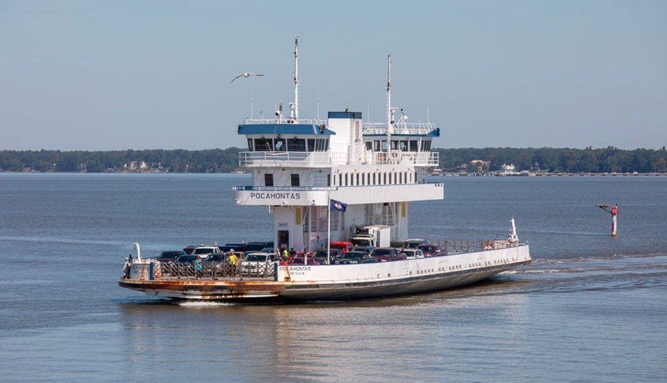
Why Tides Affect This Vital Link
The James River crossing relies on precise ramp adjustments to load vehicles safely. When tides surge, the ramps cannot connect properly to the boats, halting all traffic.
Experts point out that climate patterns have led to more frequent high tide events in recent years. In 2025 alone, Hampton Roads has seen several such incidents, up from previous seasons. This disrupts daily commutes for residents in Surry County and James City County, who depend on the free service to avoid long drives.
Tourists also feel the pinch. The ferry offers scenic views and a quick way to historic sites like Jamestown Settlement. Delays force detours that add up to 30 miles or more to trips.
Here are key factors behind these interruptions:
- Elevated water from nor’easter winds pushing tides higher.
- Safety rules that prioritize ramp stability over speed.
- Forecast changes due to shifting weather, which can extend outage times.
Traveler Impacts and Tips
Commuters faced backups on both sides of the river during the shutdown. Some reported waits of over an hour at nearby ramps, while others switched to bridges early.
Businesses in Surry, known for farms and small shops, saw fewer visitors on October 12 evening. One local ham producer mentioned slower deliveries as trucks rerouted.
To handle future delays, drivers can take simple steps. Check updates often to plan ahead. The service runs 24 hours a day normally, carrying up to 30 vehicles per trip.
Practical advice includes:
- Pack extra time for trips across the James River.
- Use apps for real time traffic views near the docks.
- Consider carpooling to ease bridge congestion during peaks.
Detailed Alternate Routes
When the ferry goes offline, state officials map out clear paths around the James River. These routes use major highways and bridges to keep travel moving.
The table below outlines the main options for getting from one side to the other. Times assume normal traffic and can vary with rush hours or weather.
| Starting Point | Route Steps | Estimated Distance | Travel Time |
|---|---|---|---|
| Surry to Jamestown | Take Route 10 to Route 258 to James River Bridge (Route 17). Follow signs for I-64 west. Exit 242A to Route 199 west toward Williamsburg. Then to Route 31 (Jamestown Road). | 25 miles | 40-50 minutes |
| Jamestown to Surry | Take Route 31 to Route 199. Right onto Route 199. Merge to I-64 east, take James River Bridge exit. After bridge, right to Route 258, then right to Route 10. Follow to Surry signal. | 25 miles | 40-50 minutes |
These paths cross the James River Bridge, a key span that handles heavy loads daily. In past events, bridge traffic spiked by 20 percent during ferry stops.
Staying Informed on Updates
As of early October 13, the ferry operates normally again. Officials urge checking the hotline at 800-823-3779 for any morning hiccups from lingering tides.
Social media posts from transportation accounts shared real time alerts on October 12, helping many avoid the area. Websites like the state traffic portal provide camera views half a mile from boarding spots.
For ongoing monitoring, download the free mobile app or dial 511 from your phone. This setup has improved response times, cutting average delay impacts by half in recent years.
If you faced delays from these tide issues or used an alternate route, share your story in the comments below. Your tips could help fellow travelers stay safe and on schedule.