The Met Office has issued a yellow weather warning for heavy rain across southern Scotland on November 11, 2025, leading to widespread flooding and travel chaos. Persistent downpours from the south are causing road spray, difficult driving conditions, and delays in rail, air, and ferry services throughout the day.
Warning Details and Timeline
Forecasters predict rain starting around 10am and lasting until midnight, with the heaviest falls expected in the afternoon. This system brings steady showers that could turn intense, especially on higher ground. Officials urge people to stay alert as conditions worsen during the evening rush hour.
The alert covers a broad swath of the country, focusing on areas prone to quick water buildup. Recent weekend rains in some spots have already saturated the ground, making today’s event more risky. Experts note this fits a pattern of unsettled autumn weather, with more wet spells likely in the coming weeks.
Rainfall Amounts and Flood Risks
Expect 20 to 40 millimeters of rain across most warned zones, but isolated hills could see over 60 millimeters by evening. Such volumes often lead to surface water pooling on roads and low-lying paths. In Dumfries and Galloway, south-facing slopes face the worst, where runoff might overwhelm drains.
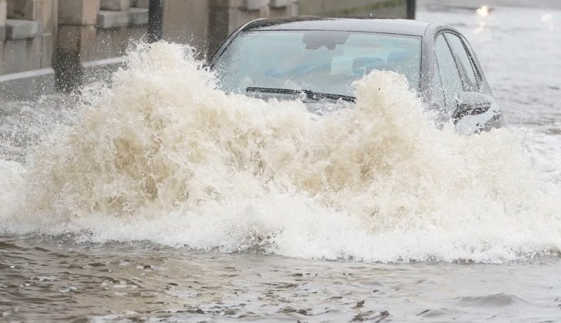
Flooding threats extend beyond roads to small streams and urban spots. The Scottish Environment Protection Agency has activated seven regional flood alerts and one local warning, signaling possible impacts into Wednesday. This builds on earlier heavy rains that caused minor issues over the weekend, highlighting how back-to-back events strain local defenses.
- Key flood risks include:
- Surface water on highways causing aquaplaning for drivers.
- Overflow from minor rivers affecting rural communities.
- Brief inundation in towns with poor drainage, like parts of Glasgow.
Affected Regions Across Scotland
Nineteen council areas fall under the warning, from the southwest coast to the central belt. Dumfries and Galloway stands out for potential severe downpours, but places like Glasgow and Edinburgh will also feel the effects. Central Scotland, including Stirling and Falkirk, braces for spray and delays.
Here’s a breakdown of key impacted zones:
| Region | Expected Rain (mm) | Main Concerns |
|---|---|---|
| Dumfries and Galloway | 40-60+ | Heavy falls on hills, high flood risk |
| Glasgow City | 20-40 | Urban flooding, road closures |
| South Lanarkshire | 20-40 | Travel delays on motorways |
| Lothian and Borders | 20-40 | Ferry and rail disruptions |
| Argyll and Bute | 20-40 | Coastal spray, extended journeys |
This table shows how risks vary by location, helping residents plan ahead. Bordering areas like Ayrshire may see lighter effects but still face spray issues.
Travel Disruptions and Safety Measures
Rail operators held emergency meetings to prepare, with speed limits planned for vulnerable tracks in the west and southwest. ScotRail warns of possible service changes, so travelers should check apps for real-time updates. Network Rail focuses on preventing slips from wet lines, which could add hours to commutes.
Roads tell a similar story, with Traffic Scotland flagging the A83, A84, and A85 for hazards. High-sided vehicles risk gusts near water buildup, and some routes may close temporarily. Air travel at Glasgow and Edinburgh airports faces minor delays from low visibility, while ferries to islands could cancel sailings.
Drivers get clear advice to handle the mess:
- Slow down and increase following distance to manage spray.
- Avoid flooded paths and turn around if water rises.
- Use headlights and wipers, but never drive through deep puddles.
These steps can prevent accidents in what promises a tough day on the move. Past events, like last month’s storms, show how quick action saves lives and eases strain on services.
Community Preparation and Broader Outlook
Local councils push for home checks, like clearing gutters and moving valuables from basements. Emergency teams stand ready, but residents play a big role in staying safe. This rain ties into wider climate trends, where wetter winters challenge infrastructure across the UK.
Looking ahead, the Met Office sees more rain in the west through mid-November, with milder temps giving way to colder snaps. People in flood-prone spots should monitor updates closely. Share your experiences in the comments below and spread this info to help others stay dry and safe during the storm.
 Windows 11 KB5095093 Lands With Point-in-Time Restore and 35-Day Pause
  Meta Cuts Smart Glasses to $299 to Outflank Snap and Apple
  Messi Leads the 2026 World Cup Golden Boot Race After Two Matches
  Australia March On as Athapaththu Ton Lights Up T20 World Cup
  Galaxy Z Fold 8 Leak Reveals Colors, Storage, and a New Ultra Variant
  Ronaldo’s Six-World-Cup Record Leads a Matchday Full of Milestones